Since the 1990s, the European Commission has supported various projects in the development, testing, and installation of multidisciplinary submarine observatories that could monitor geophysical, oceanographic, and chemical parameters at abyssal depths.
The development of seabed underwater observatories has required and still requires the overcoming of important technological challenges related to the difficult conditions in which the observatory must operate, as well as the complex logistical aspects associated with the deployment and recovery of such objects at great depths. Furthermore, the sea is also highly corrosive for the equipment installed for a long time, therefore ad hoc precautions must be implemented to safeguard their functionality as well as their operation must be guaranteed at the temperatures and pressures present at the deposition depths.
The construction and installation of deep submarine observatories constitute an essential/fundamental aspect to achieve continuous monitoring at the bottom of the sea at a fixed point, thus complementing the main feature of the more traditional methodologies of measurements at sea such as those based on ships, gliders which provide time series of spatially distributed data, but limited in time scale because in continuous movement.
Here below there is a brief description of the challenges, evolutions, and changes that have involved the various submarine observatories developed by our group over time.
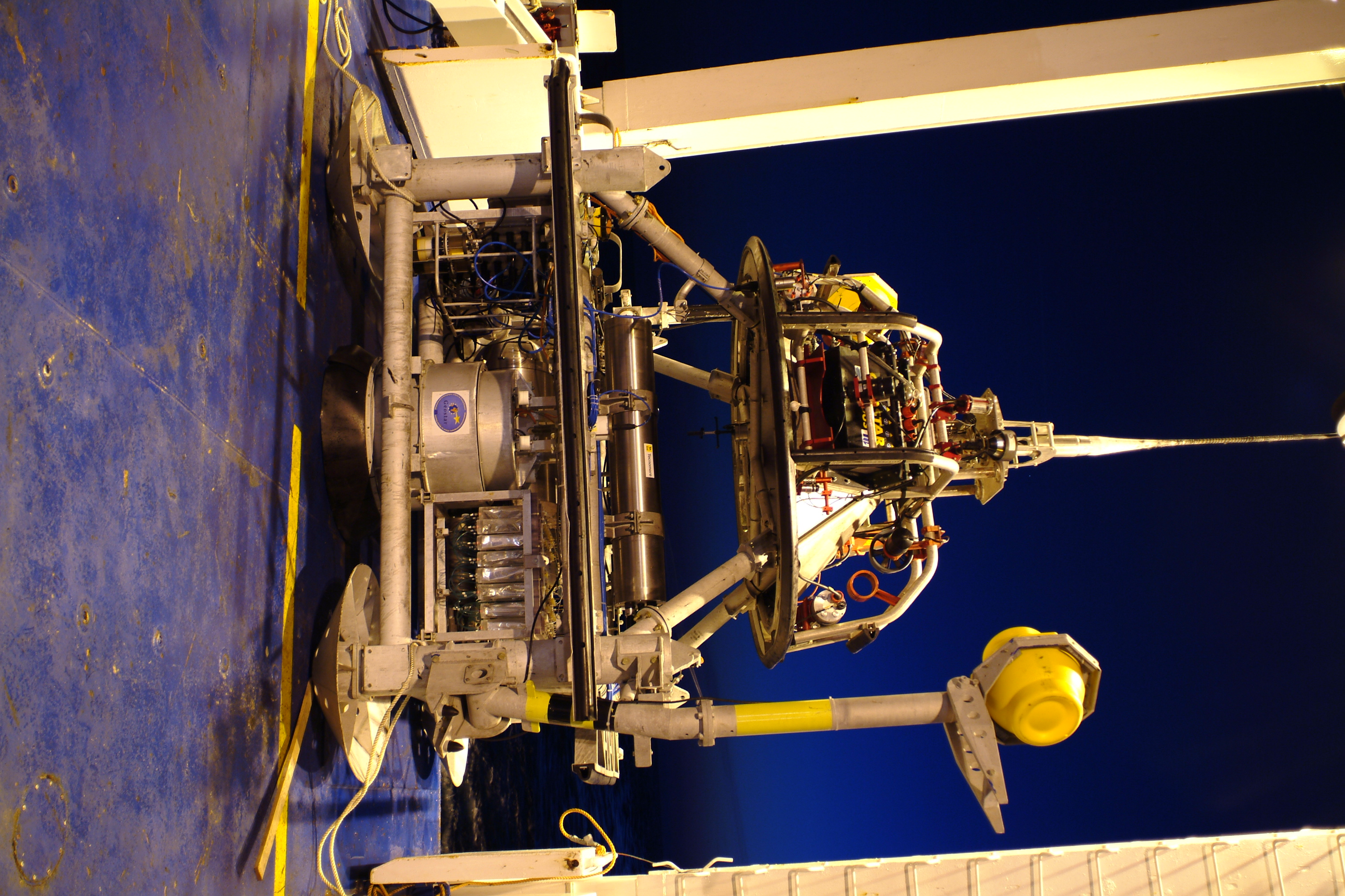
The first project funded by the European Commission was the GEOSTAR Project (GEophysical and Oceanographic Station for Abyssal Research, 1995-1998). It led to the development of the first prototype of an autonomously powered underwater observatory, via batteries, capable of performing geophysical, geochemical, and oceanographic measurements over a long period of time, months.
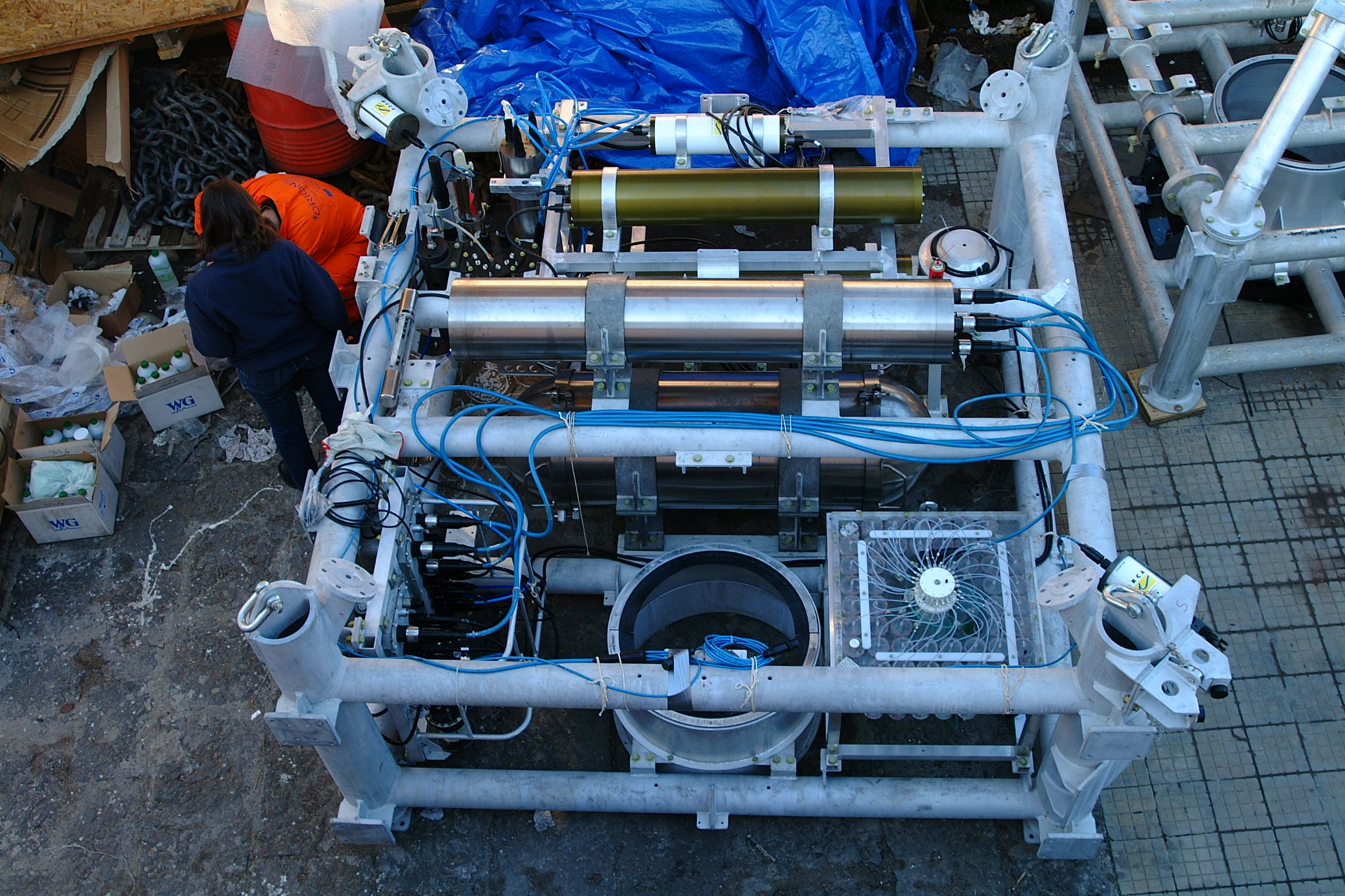
This observatory called GEOSTAR is characterized by original and innovative technological solutions including:
- a lightweight open frame made of a non-magnetic alloy (3.5m x 3.5m x 3.3m);
- active devices for the deployment of specific sensors (such as seismometer and magnetometer);
- a system dedicated to data acquisition and mission management, based on customized low-power hardware;
- ability to operate autonomously, including power management and self-diagnostics of various instrumentation;
- ability to reconfigure the instrument setup to appropriately meet the demands of different missions and deposition sites;
- the development of a dedicated vehicle for the deposition and recovery of the observatory.
.The installation of various instrumentation inside the frame has several advantages; first of all, it allows to organize a single operation for the placement (and subsequent recovery) instead of having to place one instrument at a time. This also means that all measurements are taken at a single point. Furthermore, thanks to the weight of the frame and of the instrumentation itself, the stability of the whole system at the seabed is guaranteed, thus also increasing the reliability of the measurements.
During the six Campaigns in which GEOSTAR was deployed, its scientific formatting was optimized from time to time according to the purposes of the mission and the characteristics of the deposition site. Particular attention was also gradually paid to the arrangement of the instrumentation on the frame to comply with the individual operating specifications and at the same time to minimize possible interference between the different instruments.
During the last two missions, GEOSTAR was equipped with a tsunami detection system and an original algorithm conceived and implemented by INGV, IRA-INAF (National Institute of AstroPhysics - Institute of RadioAstronomy), and by the CNR- ISMAR (National Research Council - MARine Science Institute) able to highlight the passage of tsunamigenic waves of a few centimeters. The algorithm was subsequently made operational in the installation at the Western Ionian Sea site.
GEOSTAR has always been configured to work in near real-time connection, namely with remote accessibility via underwater acoustic telemetry and a buoy, acting as a relay, moored near the observatory and connected to the ground station via radio or satellite. This buoy has limited capacity in terms of quantity and transmission bandwidth due to the characteristics of acoustic telemetry, which is why it is referred to as a near real-time connection.
The exploration potential that an observatory of this kind would have allowed was evident since the first missions. For this reason, in parallel with GEOSTAR, two other multi-parameter observatories were developed; SN1 to extend the Italian seismic network to the sea, and SN2 to test the applicability of these systems for monitoring in a polar environment. The technical solutions developed for both observatories led to the optimization of GEOSTAR features which made the observatories more manageable. It was developed:
- a smaller frame using the same procedures for deposition and recovery by cable and winch;
- a new battery pack which was placed in a smaller container (20 cm in diameter);
- a new acquisition system and electronics for mission management. This system was incorporated in a container of 15 cm diameter.
SN1, built under the GNDT Program (Italian National Group for Defense against Earthquakes) and subsequently implemented under the European project ESONET NoE was deployed in three different missions in the depths of the Ionian Sea about 20 Km from the eastern coast of Sicily at depth of just over 2000 m. The deposition site is within an underwater area characterized by important seismogenic structures, among which the most important is the Iblean-Maltese structure considered responsible for the most disastrous earthquakes in the area (Catania, 1693, and Messina, 1908).
During its first mission, SN1 was configured to be self-powered, it was equipped with batteries that powered both the sensors and the data logging system. During the mission, high-quality data (seismic, gravimetric, and environmental) were collected, demonstrating the correct functionality of the entire observatory management system, thus stimulating a further update of SN1 to make it a wired observatory. In its second mission, SN1 was tested in continuous mode by connecting it to the northern end of an INFN fiber optic cable (thanks to an agreement between INGV and INFN) which extends for approximately 25 km off the coast of Catania harbour. The cable terminates on the ground at the Laboratori Nazionali del Sud, where the SN1 ground station also resides. This version of SN1 was implemented to be powered, monitor, and transmit data to the ground station continuously without however eliminating the battery system which was supposed to take over the power supply automatically when there was a loss of power from the optical fiber and allow in this case the local storage of data. SN1 operated satisfactorily for the entire mission (which lasted about 3 years) and was successfully integrated into the Italian National Seismic Network.
Thanks to the success of the missions described above, the deposition site of SN1 was selected to become one of the underwater observation sites of the European Research Infrastructure EMSO (European Multidisciplinary Seafloor and water column Observatory) which aims at the long-term monitoring of marine environmental processes associated with ecosystems, climate change and geological hazards. To this end, SN1 was then further implemented:
- eliminating the battery support system, given the reliability of the fiber optic cable for both power and data transmission;
- to support a complete set of sensors for seismological, geomagnetic, gravimetric, accelerometric, oceanographic, hydro-acoustic, and bio-acoustic measurements.
A new ground station was installed at the INFN Southern National Laboratory in the harbour of Catania, with the acquisition system, the power supply for the underwater instrumentation, and the GPS antenna necessary for the synchronization of the measurements performed.
The subsequent MABEL project (Multidisciplinary Antarctic BEnthic Laboratory) had the objective of developing and operating continually multidisciplinary measurements for a long time in the frozen waters of Antarctica. This is because increasing knowledge of the state of the polar regions and of its phenomena is important for increasing the understanding of the conditions and dynamics of the entire planet. Seen the hostile polar environment, many efforts were made to ensure the operation of the instrumentation in the extreme arctic conditions and to reduce power consumption as much as possible. Efforts that led to the development of SN2 which in 2002 was deployed at the Hamburg Large Ice Model Basin. This test demonstrated the observatory's ability to work in extreme conditions.
So, in 2005 SN2 was installed at about 65 km from the ground station of Neumayer German Station at a depth of about 1800m. After a year of operation, the first attempt to recover the observatory failed due to adverse weather conditions. The acoustic interrogation on the operational status of SN2 demonstrated, as expected, that it was in standby. In December 2008, a new recovery mission was organized and it was successfully recovered. This mission demonstrated how polar conditions are critical for the operation of some commercial scientific sensors but this criticality can be resolved by carrying out a more careful selection and certification of the instrumentation.
Extending the monitoring space coverage of the underwater observatories, creating a network of observatories, and maintaining near real-time data transfer to the ground station was the goal of the ORION-GEOSTAR 3 Project (2002-2005). The SN3 observatory was thus implemented, with the same architecture and size as SN1 and SN2 but in such a way that it operated as a satellite of the GEOSTAR observatory. The acoustic communication system was arranged differently so that SN3 sent the data horizontally to GEOSTAR which in turn transmitted it to the ground station via the buoy. SN3 was configured in such a way that it could send the waveforms of the seismometer or hydrophone also following a specific interrogation from the ground station.
In addition to SN3, the ORION-GEOSTAR 3 project envisaged the use of another twin observatory, SN4. The latter, at the request of the European Commission, was used in the context of another project, ASSEM, which was to test and demonstrate the feasibility of a network of observatories on the seabed, which communicated with the surface via acoustic modems and transmitted data packets during their operation to a dedicated server to allow marine geo-hazard monitoring. SN4 was reconfigured in such a way that it could be deployed and recovered helped by a cable and an acoustic release system because the deposition site did not allow the use of MODUS. SN4 was also implemented to respond to queries to verify system integrity and to retrieve relevant data. The on board instrumentation of the observatory frame was organized according to the scientific objectives of the missions. Its first application was in 2005 in the Gulf of Corinth, where it was included in the network already present for monitoring the extension of the basin. The objective of SN4 was to complete the monitoring of the area from a seismological point of view. After that, three more missions involved SN4 in the Sea of Marmara whith its frame enriched with oceanographic and gas sensors aiming of finding any correlations between local or distant earthquakes and the emission of fluids in the area of which there was already evidence.
From 1995 to 2013 as many as 15 missions were carried out, with deployments up to depths of about 3300 meters and of variable duration up to 3 and a half years. The technological challenges overcome, the scientific results obtained have confirmed the validity of using deep submarine observatories to advance in the understanding of the phenomena that occur in the oceanic environment.
All the experience gained in recent years has meant that SN1 with its associated infrastructure, became part of the European Research Infrastructure EMSO - European Multidisciplinary Seafloor and water column Observatory - with the name of Western Ionian Sea.
For a more detailed reading on the different seafloor observatories developed over time, please refer to the following publications:
- Gasparoni, F. et al. (2015). GEOSTAR-class observatories 1995–2012: A technical overview. In: SEAFLOOR OBSERVATORS. Springer Praxis Books(). Springer, Berlin, Heidelberg. https://doi.org/10.1007/978-3-642-11374-1_11
- Favali, P and Beranzoli L., (2006). Seafloor Observatory Science: a review. In Annals of Geophysics, Vol. 49, No. 2/3 http://hdl.handle.net/2122/1059
 GEOSTAR multiparameter observatory ready to be deployed, December 2003
  GEOSTAR multiparameter observatory during assembly.
Buoy for almost real-time data transfer to the ground station.

SN1 recovered aboard the Nautical Tide after a mission off Eastern Sicily at a depth of about 2000 m.

Recovery of the SN2 observatory at Weddell Sea, Antarctica.
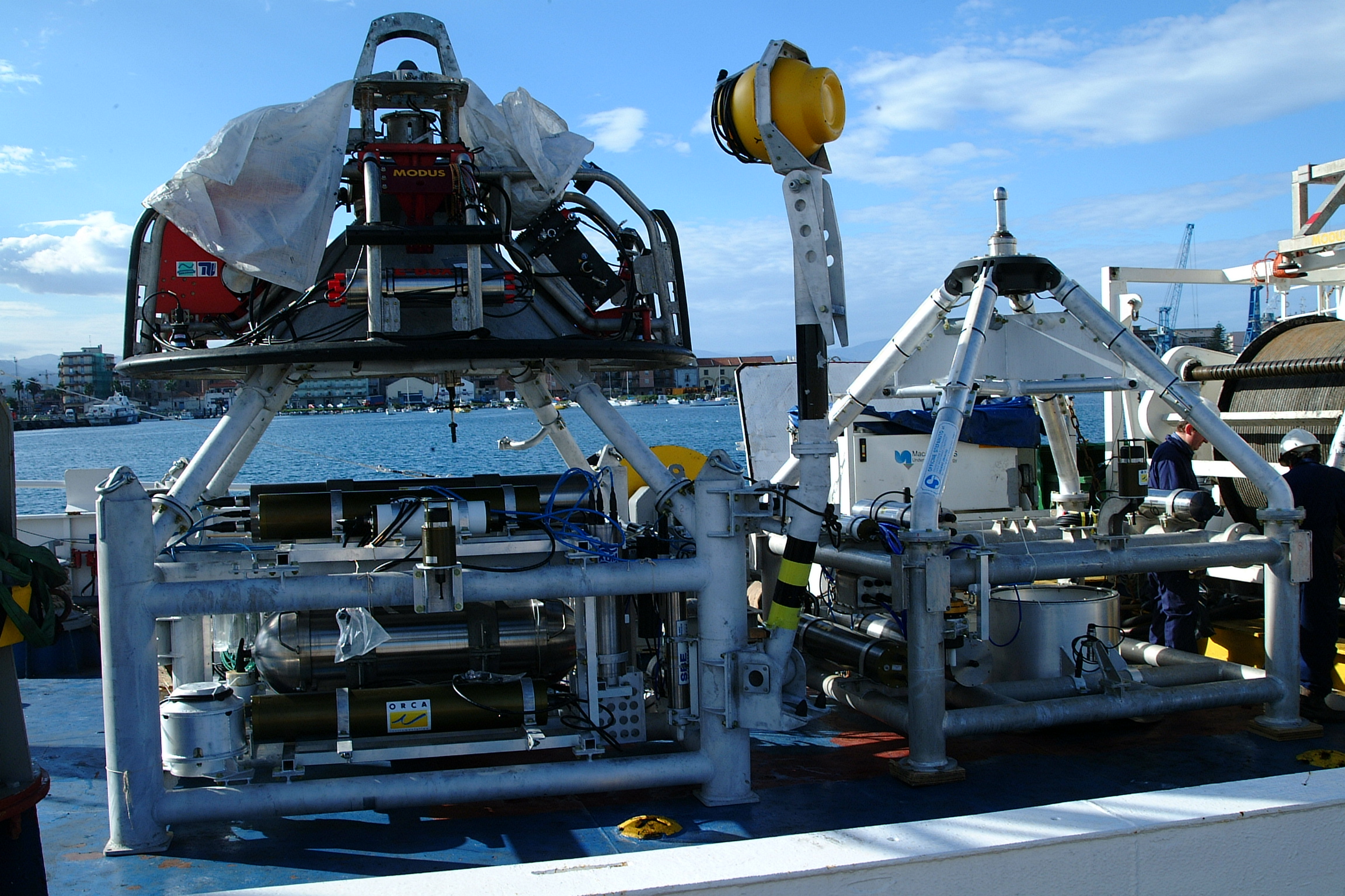
 The multiparameter observatories GEOSTAR (left) and SN3 (right) are ready to be deployed in the southern Tyrrhenian Sea in 2004.
SN4 in its configuration to be laid down in the Sea of Marmara, in 2013.


