The Western Ionian Sea platform system has experienced numerous implementations from its first development up to now.. For the optimal achievement of the scientific objectives, the modifications, the enhancements and the updates carried out on the platforms were linked both to the technological innovations that have occurred over time and to the optimization of the configuration of the platforms themselves.
Currently, the Western Ionian Sea is composed as follows:
Deep sea observatory
The seabed platform is a marine aluminum structure that hosts various instruments whose data are acquired with a single time synchronization system. The platform is powered by an electro-optical cable that starts from the ground station to reach the deposition area on the seabed. Thanks to a collaboration agreement, the management of the electro-optical cable is shared with the Istituto Nazionale di Fisica Nucleare, INFN.
The following instrumentation is installed on the current version of the seabed platform:
- integrated seismometer and accelerometer, to measure seabed movements;
- gravimeter, to measure variations in the gravitational field;
- scalar magnetometer and vector magnetometer, to measure the module and components of the magnetic field;
- CTD - conductivity, temperature, depth - to monitor the variability of hydrological parameters in deep layers. The oxygen sensor, the chlorophyll fluorometer and the turbidimeter are added to the CTD;
- ADCP – Acoustic Doppler Current Profiler, to measure how quickly the water masses move in the layers above the platform;
- High-frequency hydrophones (up to 200 kHz) for cetacean tracking;
- Low-frequency hydrophone (up to 12 kHz) to detect signals of geophysical, oceanographic, biological, and anthropic interest;
- pressure sensor, used to detect the variation in the height of the water column for the detection of possible tsunamis.
Furthermore, the platform is equipped with a DACS, data acquisition and control system. The DACS is the heart of the entire system because it controls and organizes the regular functioning of the individual instruments; it also manages the real-time transmission of the acquired scientific data to the ground station via the electro-optical cable that simultaneously supplies energy to the entire platform.
For a more in-depth read about the development of seabed observatories and on the scientific results achieved over time, please refer to the following works:
- Gasparoni, F. Furlan, F. Bruni, F. Zanon, P. Favali, L. Beranzoli, G. Marinaro, A. De Santis & H. W. Gerber, “GEOSTAR-class observatories 1995-2012: A technical overview.” October 2014 In book: Seafloor Observatories: A New Vision of the Earth from the Abyss, (pp.229-304), chapter:11
Edition: Springer-Praxis Books in Geophysical Sciences
DOI:10.1007/978-3-642-11374-1_11
Sciacca V, Caruso F, Beranzoli L, Chierici F, De Domenico E, Embriaco D, et al., Annual Acoustic “Presence of Fin Whale (Balaenopteraphysalus) Offshore Eastern Sicily, Central Mediterranean Sea.” (2015), PLoS ONE 10(11): e0141838.doi:10.1371/journal.pone.0141838 on line: https://doi.org/10.1371/journal.pone.0141838
Sgroi, T., S. Monna, D. Embriaco, G. Giovanetti, G. Marinaro, and P. Favali, “Geohazards in the Western Ionian Sea: Insights from non-earthquake signals recorded by the NEMO-SN1 seafloor observatory.” (2014). Oceanography 27(2):154–166, https://doi.org/10.5670/oceanog.2014.51. http://hdl.handle.net/2122/9100
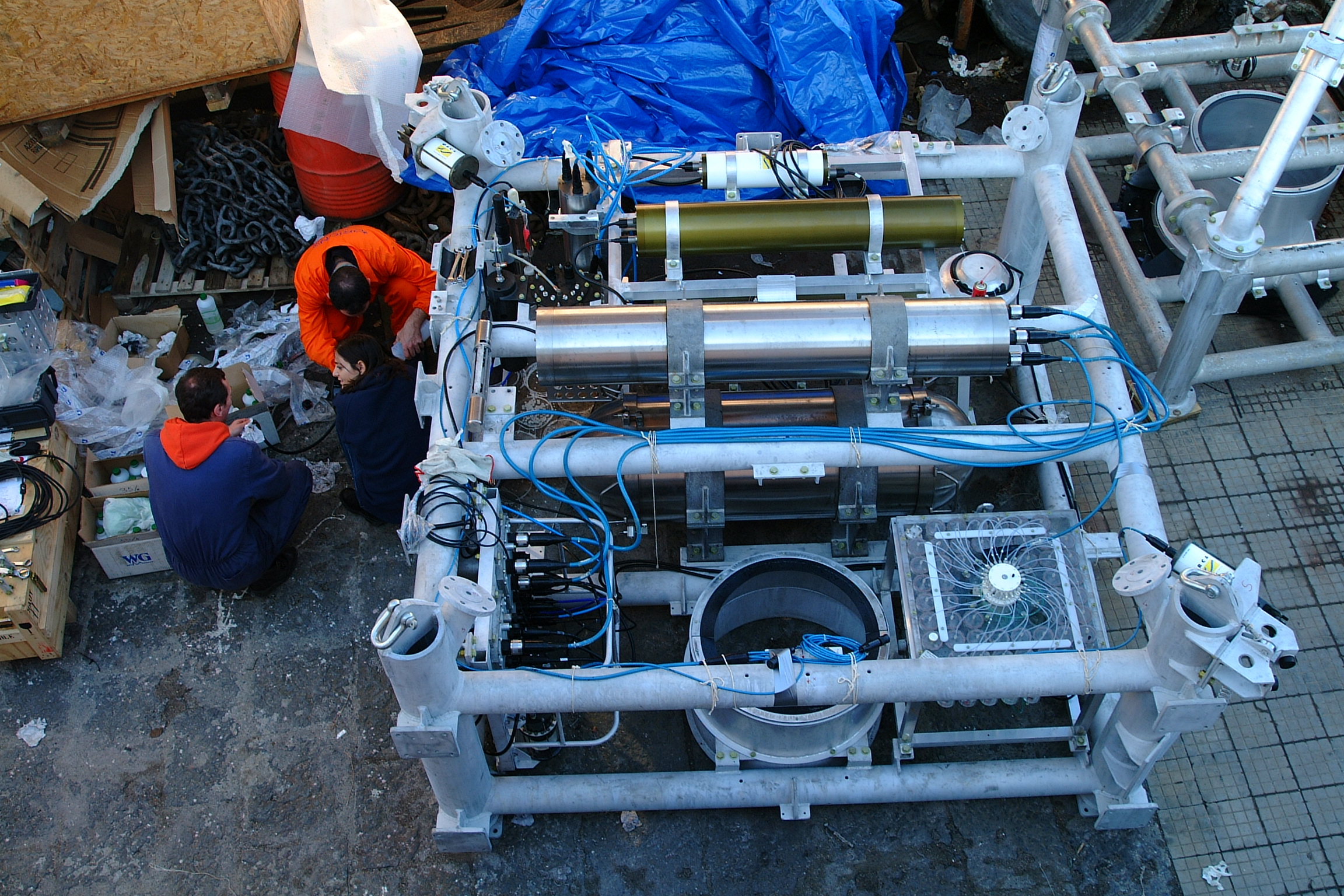
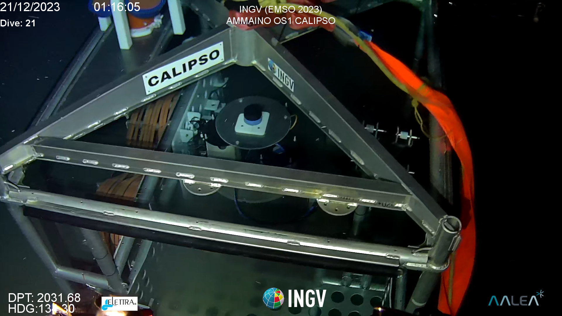 Fig.2 Seabed multiparameter platform of last generation, deployed in December 2023
Mooring
Near the seabed platform has been laid a mooring that it’s a structure anchored in the open sea designed to collect underwater environmental data such as temperature, salinity, current and other water characteristics. This structure hosts a series of sensors and measuring instruments, which are attached at various depths along a chain held in suspension by a series of floats and kept in a stable position by anchoring to the seabed. This allows the acquisition of scientific data at various depths, which will enrich the database of platform data at the seabed, thus allowing researchers to integrate measurements along the water column with data recorded at the seabed. This mooring was deposed and still managed by CNR-ISMAR and INGV jointly, thanks to a collaboration between the two institutions.
The following equipment is present in the mooring:
- CTD equipped with oxygen sensor and turbidimeter;
- ADCP;
- sediment trap;
anchored at the following depths 1985m, 1400m, 900m and 400m.
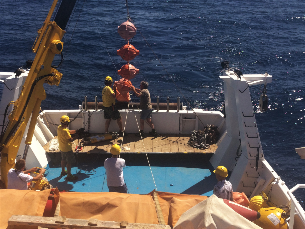
Fig. 2 Mooring deposition phase.
Smart Cable
The SMART (Science Monitoring And Reliable Telecommunications) cable is a cable similar to the numerous ones used for telecommunications, approximately 18 km long in which 3 sets of geophysical sensors are integrated. Each set is positioned inside the classic repeater of a telecommunications cable (every 6km) and each set is composed by:
- a wide-band triaxial accelerometer,
- a broadband triaxial seismometer
- a pressure sensor
- a temperature sensor.
Seafloor temperature and pressure measurements can improve estimates of ocean circulation and heat stored by the ocean floor, while combining pressure and ground acceleration measurements can improve both tsunami detection time and parameter determination hypocentral of recorded earthquakes.
This SMART Cable is the first prototype of a SMART cable laid in the world and aims to demonstrate that sets of geophysical sensors inserted into underwater telecommunications cables provide high-quality data. The enormous global underwater telecommunications infrastructure would allow a large number of instrumental sets to be inserted along their cables, thus leading to the creation of a sensor network in areas where there are currently very few instruments. This network would provide real-time data, allowing the tsunami warning system to be improved globally.
For more in-depth reading on smart cables:
Howe BM, Angove M, Aucan J, Barnes CR, Barros JS, Bayliff N, Becker NC, Carrilho F, Fouch MJ, Fry B, Jamelot A, Janiszewski H, Kong LSL, Lentz S, Luther DS, Marinaro G, Matias LM, Rowe CA, Sakya AE, Salaree A, Thiele T, Tilmann FJ, von Hillebrandt-Andrade C, Wallace L, Weinstein S and Wilcock W (2022) "SMART Subsea Cables for Observing the Earth and Ocean, Mitigating Environmental Hazards, and Supporting the Blue Economy". Front. Earth Sci. 9:775544. doi: 10.3389/feart.2021.775544
Rowe, Charlotte A.; Howe, Bruce M.; Fouch, Matthew J.; Angove, Michael; Aucan, Jerome; Barnes, Christopher R.; Bayliff, Nigel; Becker, Nathan C.; Carrilho, Fernando; Fry, Bill; Janiszewski, Helen A.; Jamelot, Anthony ;Kong, Laura S. L.; Lenz, Stephen T.; Luther, Douglas S.; Marinaro, Giuditta; Matias, Luis; Salaree, Amir; Sakya, Andi Eka; Thiele, Torsten; Tilmann, Frederik; von Hildebrandt-Andrade, Christa; Wallace, Laura M.; Weinstein, Stuart A.; Wilcock, William S. D.; Barros, Jose (2022) "SMART Cables Observing the Oceans and Earth" Marine Technology Society Journal. DOI 10.4031/MTSJ.56.5.3
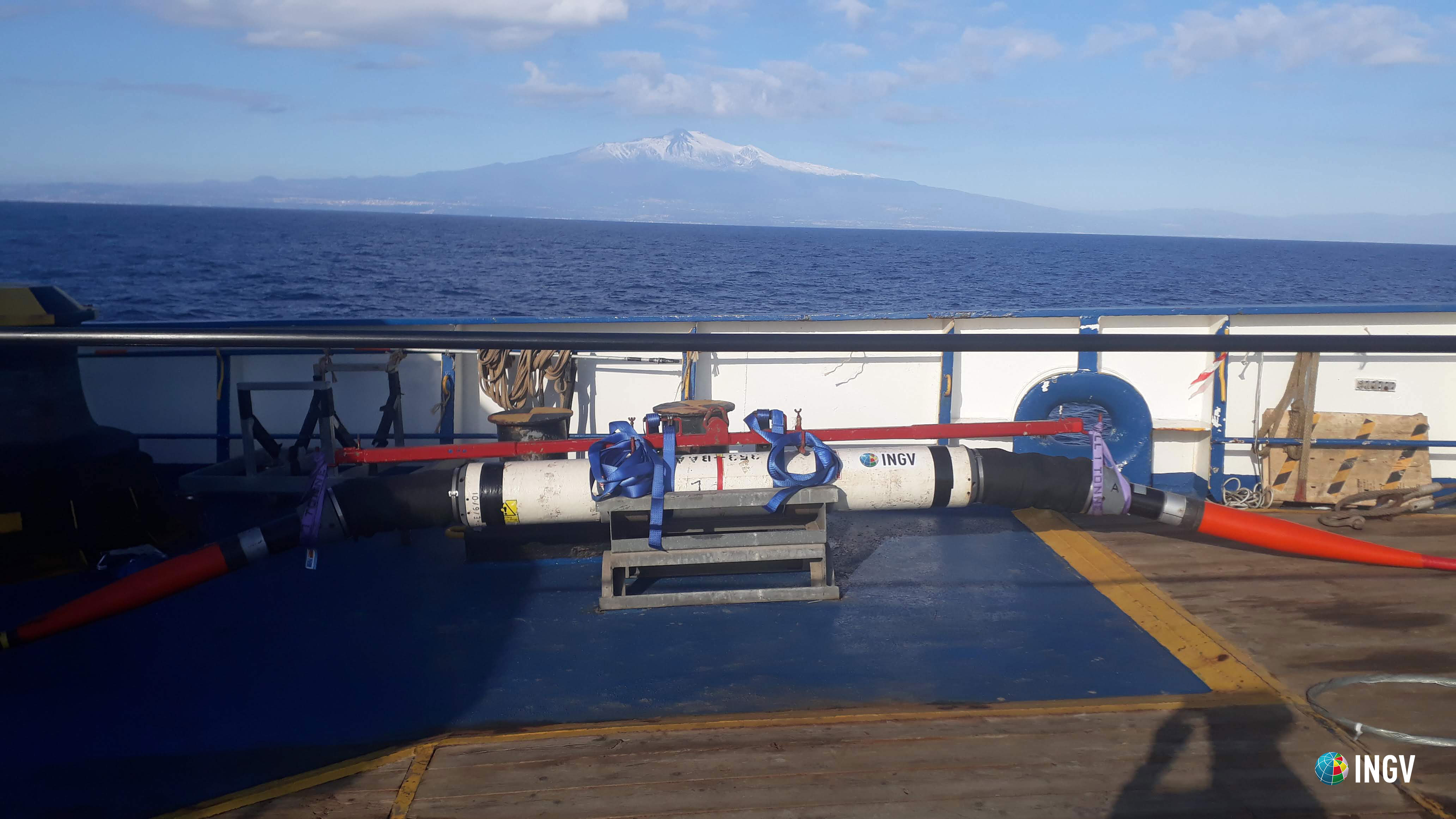 Fig. 1 A repeater of the SMART cable before its deployment. It hosts the seismic sensors.
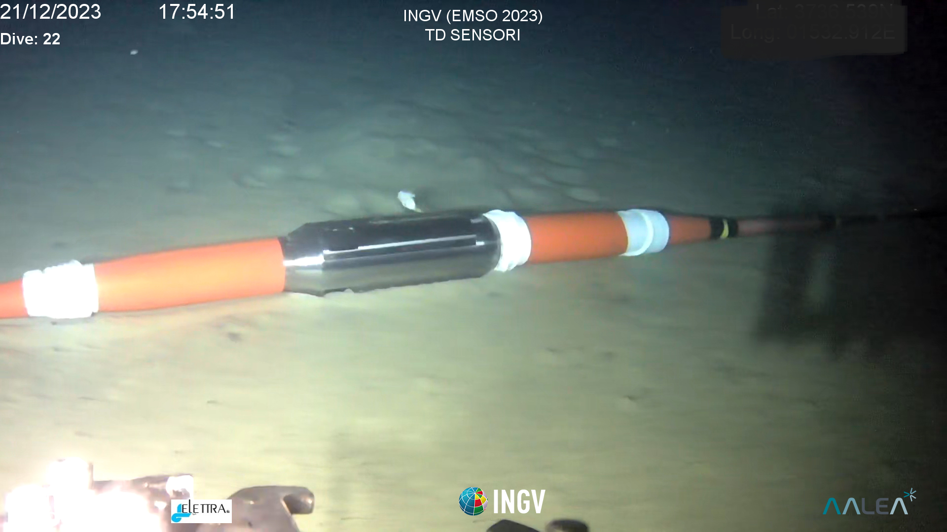 Fig. 2 A pod of the SMART cable at about 2100 m. It hosts the temperature and pressure sensors.
Optic Fiber
The electro-optical cable used for the power supply and transmission of data from the seabed observatory to land is made up of 10 optical fibers and six electrical conductors.
Optical fibers can be used as useful sensor to study the presence of deformations along the length of the optical fiber, exploiting the analysis of the transmission and reflection of the light traveling inside it and creating a non-punctual, but delocalized measurement system along the entire route of the cable. The use of these techniques will be useful to improve knowledge on tectonic and volcanic activities and landslides on the slopes of Etna.


